 |
|
|
|
|
 |
|
| Home > CT Rural Towns |
|
| CT RURAL TOWNS |
|
Download the Map (PDF / 244kb)
 |
|
The Connecticut Office of Rural Health (CT-ORH) rural definition was created for the purposes of:
1) Providing strategic direction for the planning and implementation of initiatives to fulfill its mission
2) Determining rural towns' eligibility for financial support from the CT-ORH.
The definition was revised and adopted by the CT-ORH Advisory Board in November 2022, and updated in February 2025 as a result of the change in the federal definition.
Federal agencies use multiple definitions of rural depending on specific program requirements, and individual states often develop their own definitions specific to their geographies and populations.
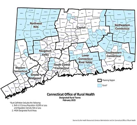
The CT-ORH defines a Connecticut town as rural if it satisfies two conditions: the total population of the town is 10,000 residents or fewer and has a population density less than 500 people per square mile. The CT-ORH also recognizes the definition set by the Health Resources and Services Administration (HRSA). There are 68 towns that meet the state's criteria for a rural designation. In addition, the CT-ORH definition includes census tracts and towns designated as rural by HRSA as of February 2025. The HRSA definition adds 5 towns and 5 census tracts/partial towns to the state definition. This combined definition includes 78 towns statewide, which are listed below by Planning Region (county equivalent).
HRSA's rural definition combines several measures of rurality from the U.S. Census Bureau, the Federal Office of Management and Budget, and its own Rural-Urban Commuting Area regions to generate its definition of rural for the purpose of grants and programs. Per the HRSA definition (see the HRSA website for specific contributing factors), the following areas are considered rural: All of Northwest Hills Planning Region, all of Northeastern Connecticut Planning Region, Census Tract 8902.01 in Stafford that is in both Capitol Region and Northeastern Connecticut, the town of Windham, Census Tract 8502 in Coventry, Census tract 8815 in Mansfield, and Census Tract 9800 over Bradley International Airport.
Readers are advised to check the HRSA website for the most up-to-date definitions, or to check if their area is covered under HRSA's rural definition for federal grant eligibility, by checking the Am I Rural Tool on the Rural Health Information (RHIhub) website.
Below is a list of CT rural towns by Planning Region:
|
|
| Planning Region |
|
Town |
|
| Capitol Region |
|
Andover, Bolton, Columbia, Coventry (partial), East Granby, Hebron, Mansfield (partial), Marlborough, Stafford (partial), Suffield (partial), Willington, Windsor Locks (partial) |
|
| Greater Bridgeport |
|
Easton |
|
| Lower Connecticut River Valley |
|
Chester, Deep River, Durham, East Haddam, Haddam, Killingworth, Lyme, Middlefield, Old Lyme, Portland, Westbrook |
|
| Naugatuck Valley |
|
Bethlehem, Middlebury, Woodbury |
|
| Northeastern Connecticut |
|
Ashford, Brooklyn, Canterbury, Chaplin, Eastford, Hampton, Killingly, Plainfield, Pomfret, Putnam, Scotland, Sterling, Thompson, Union, Voluntown, Woodstock
|
|
| Northwest Hills |
|
Barkhamsted, Burlington, Canaan, Colebrook, Cornwall, Goshen, Hartland, Harwinton, Kent, Litchfield, Morris, New Hartford, Norfolk, North Canaan, Roxbury, Salisbury, Sharon, Torrington, Warren, Washington, Winchester
|
|
| South Central Connecticut |
|
Bethany, Woodbridge
|
|
| Southeastern Connecticut |
|
Bozrah, Franklin, Lebanon, Lisbon, North Stonington, Preston, Salem, Sprague, Windham |
|
| Western Connecticut |
|
Bridgewater, Redding, Sherman |
|
|
| |
 |
|
| to top |
|
| |
 |
|
|
|
|
|